Arbeitsblatt: Satnavs, Unit 5.3, New Inspiration 2
Material-Details
Richtige Reihenfolge soll gefunden werden zum Text auf S.66 im NI2 zu Satellite Navigation Systems. Mit Lösungen
Englisch
Lehrmittel
7. Schuljahr
2 Seiten
Statistik
182545
803
7
14.08.2018
Autor/in
Eliane Lichtensteiger
Land: Schweiz
Registriert vor 2006
Textauszüge aus dem Inhalt:
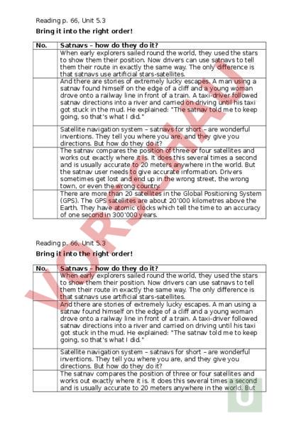
Reading p. 66, Unit 5.3 Bring it into the right order! No. Satnavs – how do they do it? When early explorers sailed round the world, they used the stars to show them their position. Now drivers can use satnavs to tell them their route in exactly the same way. The only difference is that satnavs use artificial stars-satellites. And there are stories of extremely lucky escapes. man using satnav found himself on the edge of cliff and young woman drove onto railway line in front of train. taxi-driver followed satnav directions into river and carried on driving until his taxi got stuck in the mud. He explained: The satnav told me to keep going, so thats what did. Satellite navigation system – satnavs for short – are wonderful inventions. They tell you where you are, and they give you directions. But how do they do it? The satnav compares the position of three or four satellites and works out exactly where it is. It does this several times second and is usually accurate to 20 meters anywhere in the world. But the satnav user needs to give accurate information. Drivers sometimes get lost and end up in the wrong street, the wrong town, or even the wrong country. There are more than 20 satellites in the Global Positioning System (GPS). The GPS satellites are about 20000 kilometres above the Earth. They have atomic clocks which tell the time to an accuracy of one second in 300000 years. Reading p. 66, Unit 5.3 Bring it into the right order! No. Satnavs – how do they do it? When early explorers sailed round the world, they used the stars to show them their position. Now drivers can use satnavs to tell them their route in exactly the same way. The only difference is that satnavs use artificial stars-satellites. And there are stories of extremely lucky escapes. man using satnav found himself on the edge of cliff and young woman drove onto railway line in front of train. taxi-driver followed satnav directions into river and carried on driving until his taxi got stuck in the mud. He explained: The satnav told me to keep going, so thats what did. Satellite navigation system – satnavs for short – are wonderful inventions. They tell you where you are, and they give you directions. But how do they do it? The satnav compares the position of three or four satellites and works out exactly where it is. It does this several times second and is usually accurate to 20 meters anywhere in the world. But the satnav user needs to give accurate information. Drivers sometimes get lost and end up in the wrong street, the wrong town, or even the wrong country. There are more than 20 satellites in the Global Positioning System (GPS). The GPS satellites are about 20000 kilometres above the Earth. They have atomic clocks which tell the time to an accuracy of one second in 300000 years. Reading p. 66, Unit 5.3 Bring it into the right order! Solution No. 1 Satnavs – how do they do it? Satellite navigation system – satnavs for short – are wonderful inventions. They tell you where you are, and they give you 2 directions. But how do they do it? There are more than 20 satellites in the Global Positioning System (GPS). The GPS satellites are about 20000 kilometres above the Earth. They have atomic clocks which tell the time to an accuracy 3 of one second in 300000 years. When early explorers sailed round the world, they used the stars to show them their position. Now drivers can use satnavs to tell them their route in exactly the same way. The only difference is 4 that satnavs use artificial stars-satellites. The satnav compares the position of three or four satellites and works out exactly where it is. It does this several times second and is usually accurate to 20 meters anywhere in the world. But the satnav user needs to give accurate information. Drivers sometimes get lost and end up in the wrong street, the wrong 5 town, or even the wrong country. And there are stories of extremely lucky escapes. man using satnav found himself on the edge of cliff and young woman drove onto railway line in front of train. taxi-driver followed satnav directions into river and carried on driving until his taxi got stuck in the mud. He explained: The satnav told me to keep going, so thats what did.